
The East St. Louis Columbia & Waterloo Railway
by Stephen M. Scalzo
Headline image: Car 4 is shown at an unknown location and date, though this is surely in the first year or two of the EStLC&W's life, with a company outing. This is the only photo on hand that shows one of the deck roof cars and one of the short-lived railroad roof combines, barely visible at the right edge, operating alongside each other. All photos are from the Stephen Scalzo Collection of the Illinois Railway Museum except where noted.
Waterloo, the county seat, and Columbia were two farm communities in Monroe County, Illinois, located 22 and 14 miles respectively south of East St. Louis, which was a lively industrial suburb located at the east approach of the Eads Bridge over the Mississippi River from St. Louis. As the St. Louis and East St. Louis industry grew, people from outlying areas moved to the metropolitan area for employment. By 1906, it had become evident that a more convenient means of transportation beside the Mobile & Ohio Railroad steam passenger service was needed.
The East St. Louis & Suburban Railway system soon consolidated the local streetcar system in East St. Louis with the interurban lines radiating to the north and east to Alton, Belleville, Collinsville, Edwardsville, Granite city, Lebanon, and O'Fallon. However, that system had little interest in extending trackage to the smaller, less populated area to the south of East St. Louis. The Illinois Traction System built its trackage from its own Mississippi River bridge crossing to the north and east. It became apparent that if the communities south of East St. Louis wanted better transportation, the people in Monroe County would have to build a system.
On August 31, 1906, the East St. Louis Columbia & Waterloo Railway Company was incorporated with $10,000 capital raised by Columbia and Waterloo interests. Arrangements were made for the construction of the system to Waterloo, with further plans to extend to Cairo via Red Bud, Sparta, and Murphysboro. However, the raising of sufficient capital for constructing the trackage would take six years. By July 1908, enough money was gathered to start surveying, and the route was laid out. It was determined that there were not many engineering problems, as most of the line would be built in flat flood plains, except for the hills into Columbia. Three steel bridges were needed to cross over steam railroads.
The capital stock of the company was increased to $750,000 in 1909, and all but five shares were sold to the Merchants and Manufacturing Investment Company, thus solving financing problems. The acquisition of the right-of-way began and contracts were awarded for the purchase of rail and construction of the bridges. In February of 1909, the company applied to the East St. Louis city council for a franchise to build trackage on 19th Street from the southern city limits to Bond Street to connect with the East St. Louis Railway tracks.
Construction of the line was scheduled to begin in May of 1909, but difficulties in obtaining the right-of-way held up work considerably, and it was not until May 1911 that actual construction began. Although a construction crew was put to work at the East St. Louis end in late July 1911, only about 3,000 feet of trackage was built. Construction of the steel trestle over the Illinois Central Railroad near the East St. Louis city limits was started by the George C. Smith and Sons Company (that company also constructed the other two bridges). In late August 1911, grading commenced on the right-of-way by the J.A. Ware Construction Company through the rural area south of East St. Louis, and construction continued in earnest throughout the winter of 1911-12 (interrupted for short periods due to the weather). Trackage construction was completed on Main Street in Columbia during the end of 1911.

The EStLC&W had several sizable bridges. This may be the bridge over the M&O northwest of Columbia, about where today Route 3 intersects Palmer Road.
In February of 1912, as construction progressed, trackage rights were obtained over the East St. Louis Railway from the city limits across the Eads Bridge to the foot of Washington Street in St. Louis. The Westinghouse Electric Company received the contract for the installation of the electrical equipment with which interurbans would operate; transmission wires could carry 13,200-volt, three-phase, 25-cycle alternating current, and the substations would convert the power to 600-volt direct current power that would be fed to the overhead. No powerhouse was built because electricity for the overhead was to be purchased from the East St. Louis & Suburban Railway Company. Construction of the company's offices and carbarn was started in March of 1912 at 19th and Baker Streets in East St. Louis.
On May 24, 1912, the first interurban operated over the 11 miles of trackage from the 19th Street and Bond Avenue station (several blocks from the business district) in East St. Louis to Dupo. The first three interurbans, built for the Alton Jacksonville & Peoria interurban system, were of heavy construction for double-ended operation, with railroad roofs. However, those original interurbans were soon replaced with streetcar-type interurbans that were not constructed of the usual heavy suburban standards because of the need for lightweight equipment that could operate across the Eads Bridge into St. Louis. The old interurbans were then sold to the Nipissing Central Railway in Canada. No fares were collected as an introductory gesture until June 1, when the five interurbans of the company began half-hour schedules with a 10-cent fare (it cost an additional five cents to transfer to an East St. Louis streetcar or an additional 10 cents to cross the Eads Bridge).

Handsome car 20 was one of the heavy combines built for the Alton Jacksonville & Peoria and used only briefly by the EStLC&W. The location is unknown; the car may be pulling out of one of the line's handful of stub terminal tracks or this could be at the carbarn in East St. Louis.

Construction of the right-of-way, trackage, and overhead continued south toward Columbia. Steam locomotive work trains were used to deliver bridge material for the steel viaduct at Millstadt Junction over the Mobile & Ohio Railroad northwest of Columbia, and that construction was completed in July of 1912. After the substation was completed in Dupo, which housed two rotary converters, interurban service was extended to Columbia on August 12, 1912, with an additional 10-cent fare being charged from Dupo to Columbia.

Four of the line's five deck roof interurban cars are lined up on Main Street at Kunz Street in Columbia on August 27, 1912, to celebrate the opening of the line to that city.

To celebrate the opening of the line into Columbia, the company sponsored an all-day picnic in Jones Park in East St. Louis on August 27 in cooperation with the East St. Louis & Suburban Railway, with through interurbans being operated that day directly to and from the park for a 30-cent round trip fare. In the fall of 1911, daily express service was inaugurated between East St. Louis and Columbia, and it quickly became popular; the rate was 10 to 15 cents per cwt, which was considerably cheaper than that offered by the steam railroads.
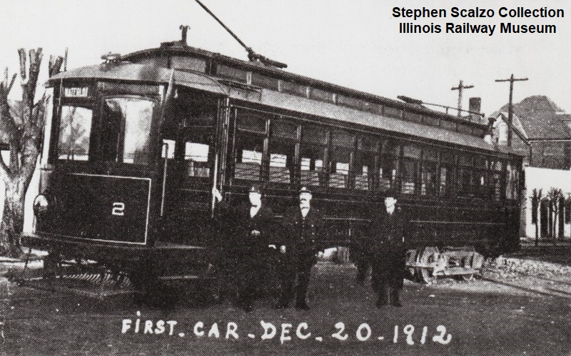
Construction progressed on the line south to Waterloo during 1912. Steam work trains began operating to Rohm carrying steel for the viaduct over the Mobile & Ohio Railroad, and work began on the second substation (which would house two rotary converters) at Lutz near Rapps Station that was located on the Gilmore Lake Road between Columbia and Waterloo. The first interurban operated into Waterloo on December 18 carrying freight for two local businessmen. On December 20, interurban number 2 entered Waterloo to commence the 22 miles of passenger service from East St. Louis. At first, only seven round trips were made daily between East St. Louis and Waterloo, with interurbans operating every 80 minutes on Sundays. However, after the Lutz substation was completed, 80-minute daily service was offered effective January 19, 1913. Construction of the line to Waterloo cost about $850,000.

Car 2 is shown on the first day of service to Waterloo, December 20, 1912.

It's December 20, 1912, and we're at the northwest corner of Courthouse Square in Waterloo, looking northeast as car 5 prepares to depart for East St. Louis. The building in the right background still stands.
On June 26, 1913, the company was operating seven daily round trips with hourly service that had been extended to Third Street and Broadway in East St. Louis, where a stub track was constructed south from Broadway onto Third Street so that the interurbans could terminate their runs. The new arrangement eliminated the need for passengers to transfer to the local streetcars to reach the East St. Louis business district. After that, patronage increased dramatically.
During 1913 the company put into service three more heavy interurbans [sic], two trailers, and one express car. Sunday crowds, especially in the evening, required additional tripper service. Carload freight service was also instituted, and during 1913-1914, a number of industrial tracks were built in Waterloo, Columbia, and Dupo. Express car number 501, capable of pulling 10 to 15 freight cars, began operating in mid-1913. To improve safety along the line, two sets of signals were installed during 1913-1914 to protect two long sections of curving trackage on each side of Columbia.

Car 1 is at the same location as the previous photo, Main Street just north of Mill Street in downtown Waterloo. This photo may also date to December 20, 1912, or sometime shortly thereafter.

In September 1913, 90-minute service was instituted to replace the 60-minute service that had been provided throughout that summer, with hourly service on Sunday. Sixty-minute service was resumed during the summer of 1914. However, on October 25, 1914, a permanent 90-minute headway with 14 round trips was adopted, with additional service being handled by trailers and trippers. On June 5, 1915, interurban service was extended over the Eads Bridge into St. Louis. As a result of the extension of service and subsequent patronage boom, the company was able to increase all employees' wages by 2.5 cents an hour on January 1, 1917.
Business steadily improved into 1920. Express revenue of $17,331 in 1920 was more than triple that of 1914. Patronage of 612,842 in 1923 was about double the number carried in 1913. Sidings were built to various coal yards and breweries in Columbia and Waterloo, and between 1914 and 1924 freight revenues grew to $37,857. Freight traffic as a bridge carrier bolstered passenger earnings, and the system connected with the Terminal Railroad Association of St. Louis, the Alton & Southern Railroad, and the Mobile & Ohio Railroad that it crossed, offering an attractive bypass route for certain movements. By 1924 the company grossed $221,568. Ownership changed hands when a St. Louis syndicate, headed by Charles H. Lamp, purchased the company from the Merchants and Manufacturing Investment Company for $325,000.

Car 5 stands ready to take on passengers on the west side of Courthouse Square in Waterloo. Annoyingly, every single one of the EStLC&W photos in the Scalzo Collection appears to date from the first year or two of the line's history. There are no pictures at all of the company's later years.

With the concrete paving of Illinois Highway 3 between East St. Louis and Waterloo in 1925, passenger business fell rapidly and the economic health of the company deteriorated. Expenses in that period of economic inflation could not be cut enough to compensate for lost revenue. The company lost money in 1926, and after that it never made a profit. In 1929, the St. Louis Red Bud and Chester Motor Bus Corporation extended bus service from Waterloo to East St. Louis. As a result, passenger revenues dropped off so severely that all hope for recovery was lost. Ridership dropped from a 1923 peak of 612,842 to 222,482 in 1931.
Express service was also affected by Illinois Highway 3. Competing truck lines took away so much of the parcel freight business that revenue in 1928 was less than $1,000. Application was made during the summer of 1929 to the Illinois Commerce Commission to drop all express service, with permission being granted on November 5. Carload freight revenues remained high and profitable during that period, so the company decided to concentrate on that aspect of the business. A small amount of revenue was also realized from a 1926 contract with the Post Office to carry mail between St. Louis and Waterloo, and that service remained until 1932.

Perhaps the most modern car on the system, handsome steel express motor 300 came from St. Louis Car Company in 1920. Krambles-Peterson Archive.

Bus competition and the continued use of the automobile, plus the economic problems of the Depression, worsened the situation. Despite schemes that lowered fares and sped up service, the passenger loss could not be halted. When the competing bus line applied in March of 1932 to extend service into St. Louis, the company decided not to oppose the petition, and instead applied for permission to drop passenger service. Permission was granted quickly, and the last interurban to carry passengers operated on June 1, 1932.
With the abandonment of passenger service, freight service continued. Carload freight continued unchanged, except that the trackage rights agreement with the East St. Louis Railway was cancelled. However freight revenue, while increasing a small amount, could not cover the cost of operations during the Depression. Bankruptcy was declared on October 31, 1934, but losses continued to grow. On December 31, the company claimed to have only $191 in cash on hand to pay bills totaling $40,000. Earnings declined from a 1929 peak of $221,568 to $22,087 (-$8891 net) by 1936. The company had no alternative at the beginning of 1936 but to apply for abandonment. After hearings were held at which little interest was shown by anyone in the continuation of service, permission was granted on April 11 and all service was terminated on August 1, 1936.
In order to raise money to pay off the company's debts, all property was sold at public auction on June 29, 1936. Most of the right-of-way was sold to Monroe County for $16,000, and the land was used to straighten Highway 3. The rail, overhead wires, car shed, stations, and rolling stock were sold to Joseph Schonthal Company of Columbus, Ohio, for scrap or resale for $58,000, and the system was dismantled shortly after service was terminated. However, the $74,000 realized from that sale barely covered half of the $145,000 that the company owed. The rails in city streets remained until World War II, at which time they were removed for the war effort.
This article was edited and laid out by Frank Hicks. Thanks to Ray and Julie Piesciuk and to Richard Schauer for making available the materials from the Stephen Scalzo Collection that were used to publish this history.
Equipment Roster
This is not a complete roster
Cars 20-22 (three cars) - DE DT RR interurban combines - built 1911 by American (order #892) - Brill 27MCB2 trucks - built for Alton Jacksonville & Peoria but never delivered, acquired by EStLC&W in 1911, resold by EStLC&W to Nipissing Central Railway as their 22, 24, and 26
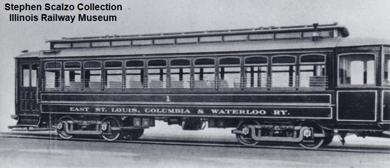
Cars 1-5 (five cars) - DE DT DR interurban coaches - built 1911 by American (order #924) - Brill 27MCB1 trucks, 4 x GE 203 motors, 48 seats
Car 200 (one car) - DE DT AR baggage/express motor - built 1912 by American (order #945)
Cars 30-31 (two cars) - DE DT RR open trailers - built 1913 by American (order #996) - Brill 27MCB2 trucks - 14-bench wire-side trailers
Car 501 (one car) - express car - acquired 1913
Car 300 (one car) - DE DT AR baggage/express motor - built 1920 by St. Louis Car Co. (order #1253) - St Louis 23ES trucks
Car 1 is shown in a lopped-off builder's photo.
Car 2 is in Waterloo on the first day of service there.

Heavy combine 21 is shown in operation at the same unknown location as the earlier photo of sister car 20.


Timetables
A June 1913 souvenir timetable has been made available online at this website and is a wonderful view into the railway and the communities it served in the years before World War I.

By September 1913, the line was on its fifth timetable. Travel from Waterloo to the terminal in East St. Louis took an hour and 15 minutes.

Service in 1923 had been sped up slightly; a trip over the entire line still took an hour and 15 minutes, but now included a journey over the Eads Bridge into St. Louis itself.

The date of this timetable is uncertain; a handwritten note includes the date May 4, 1932, but that is far from certain to be accurate. Whatever the date, service has been sped up yet again, with some trips making the journey from Waterloo to St. Louis in an hour and five minutes.
Route Map

The carbarn, pictured on page 3 of the 1913 souvenir timetable linked in the previous section, was a sizable brick structure located on the north corner of 19th and Baker in East St. Louis. It survived into the 1950s. It's shown in this Sanborn Fire Insurance map, drawn sometime after the interurban line was abandoned and the building was purchased by a boiler company. Northwest is top, northeast is right.


1 comment:
I grew up in Waterloo in the 1960's and 1970's, moved away the fall of 1976. My best friend lived in the strip of ranch homes along the west edge of Route 3 (now old Rt. 3) north of Rau's IGA, the nursery and greenhouse, and the Ford dealership that, in the 1970's, anchored the north edge of town. (The open field across Route 3 east of his house would eventually become the site of the first Wal-Mart, now the Rural King.) This was back when W.J. Zahnow Elementary School first opened.
We used to explore the treeline across the field west of his backyard. From the highway, it just looked like another treeline. But once you walked through the initial line of ground scrub and low-hanging branches, you entered a wide-open green tunnel of branches formed by the growth on either side of the old right-of-way. We were told it was an old trolley line, but the rails and ties were long gone; we might have found an old spike or two. The right of way did still have a generous amount of cinders mixed into the dirt underneath the weeds, and you could trace where the line entered the town.
For a couple of young grade school boys who spent way too much time watching Hogan's Heroes, the ability to just duck into that canopy tunnel and disappear from outside view, held an irresistible sneaky cool factor. We even tried to dig a tunnel one afternoon in what I would learn years later was the middle of the right of way. It was a lot more like work than they make it look like on TV, especially trying to dig into the compacted, rock-hard, cinder-laden right-of-way. After an hour or two, we barely made a scratch, a strip about 2 feet long and maybe 3-4 inches deep. We lost interest and found something better to do, pretending we were soldiers hiding in a Normandy hedgerow, keeping a lookout for those dreaded Panzer tanks.
We were told that the unusually wide open spot of pavement in front of what was by then the Monroe County Historical Society's Peterstown House where Main and Market intersected with Columbia Avenue, was where a turntable had been located back in the day, but were never able to confirm it. This is the site now occupied by the State Bank and parking lot. Back then, it was just a large oddly-shaped paved spot. To this day, I don't know if that information about a turntable is accurate.
Thank you so much for sharing the photos and information, and plugging so many gaps in my childhood knowledge. What a wonderful place and time to grow up in!
Post a Comment